)
)

How two innovative start-ups are using Ordnance Survey data to help the emergency services save lives
Henry Sternberg, founder of Blue Light Maps, and Nick Sutton, founder of EmergencyLocate, are committed to improving support to emergency control rooms and responders – drawing on their direct personal experience in police and ambulance services.
Blue Light Maps
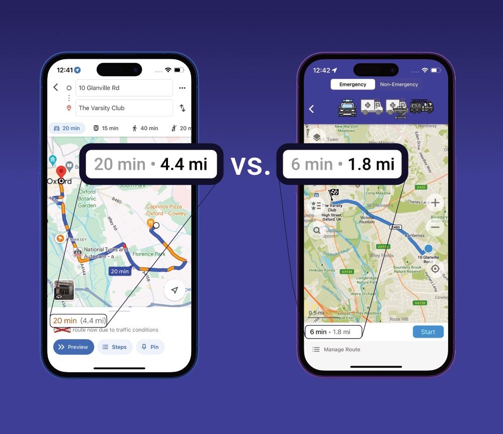
Henry, who previously led innovation projects in financial services, now works full-time on his app whilst also serving as a special constable for 13 years. Blue Light Maps focuses on routing and navigation to incidents, leveraging OS average speed data, and includes three main features:
- Blue light routing: this identifies the fastest routes for emergency vehicles, including roads normally restricted to the public (e.g. bus lanes, restricted turns, pedestrian areas), where emergency service exemptions apply.
- Consolidated geospatial data: improved situational awareness by combining OS National Geographic Database (OS NGD) address and building data with Google Street View and custom emergency service data (e.g. fire hydrant locations).
- Driver alerts via Waze: uses Waze to alert other drivers of
approaching emergency vehicles, helping reduce blue light collisions—of
which there are over 4,000 involving police vehicles annually.
Henry explained that the app was inspired by his own experiences and the critical importance of trusted, detailed location data in emergency response:
“When I was first trained to drive on blue lights, lots of new active travel schemes like Low Traffic Neighbourhoods were implemented in the area I policed. I realised that the navigation apps I relied on were taking me on longer routes, even though as an emergency service driver I was still allowed to use the old shortcuts. When I looked into this, I was amazed at how big a problem this was across the country and realised there was a vital gap in mapping solutions designed for frontline emergency services personnel. That inspired me to create a solution.”
He also stressed the importance of accurate location data in navigation and routing:
“I was once delayed finding the victim of a stabbing because I didn’t have access to detailed maps of an estate. Detail really matters. OS NGD lets us map house numbers and blocks clearly – whether council estates or farmhouses – areas consumer apps often struggle with. And while control rooms have this OS data, frontline staff often don’t.”
Dorset and Wiltshire Fire and Rescue Service has rolled Blue Light Maps out to all fire appliances with custom hydrant and fire risk data overlays.
"We have been using the Blue Light Maps app in 40 of our specialist frontline vehicles for a number of weeks and it has already made a positive difference in reaching incidents more quickly and effectively. We often deploy firefighters from wider operational areas who may be unfamiliar with the local road network so having a way of quickly selecting the most suitable route for them can be timesaving. We are currently exploring opportunities to expand the use of the Blue Light Maps app to all responding officers, which will further improve their situational awareness and response efficiency."
Geovation Accelerator Programme
Both founders have had invaluable support and mentorship from the Geovation Accelerator Programme. Henry was successful in the Spring 2023 cohort, while Nick is still in the Geovation Scotland programme – and won the Scottish Geospatial Technology Award from the organisation last year.
Nick said: “The Accelerator programme has been instrumental in helping me to develop my ideas into a life-saving solution. It has opened my eyes to the support available for founders in geospatial, tech and far beyond. The support from OS has been incredible and I’ve been coached by absolute rockstar mentors, a few of whom have agreed to continue to support me when my cohort ends.”